

 Amazing and powerful spirit
from Lauca to Hornocal via San Pedro de Atacama
➥ East Area - Tilcara-Stage
Year: August 2018
Countries: Chile, Argentina
Km: 4708
Vehicle: Volkswagen Amarok 4x4
Camera: Sony A7
Directing: GPS with OpenStreetMap
Planning & arranging: Self
Driving: Self-drive
in bold location to stay
Back to first part of the journey (Putre stage)
- Calama
- -> Iquique
- -> Putre
- Parque Nacional Lauca (Cotacotani, Chungarà)
- Volcan Taapaca, Quebrada Allane, Quebrada Colpita & Suriplaza
- Volcan Guallatiri & Monumento Natural Salar de Surire
- Parinacota & other pueblos (the info about such Andean Publeos are spread around the 3 day-trips above)
Back to first part of the journey (Putre stage)
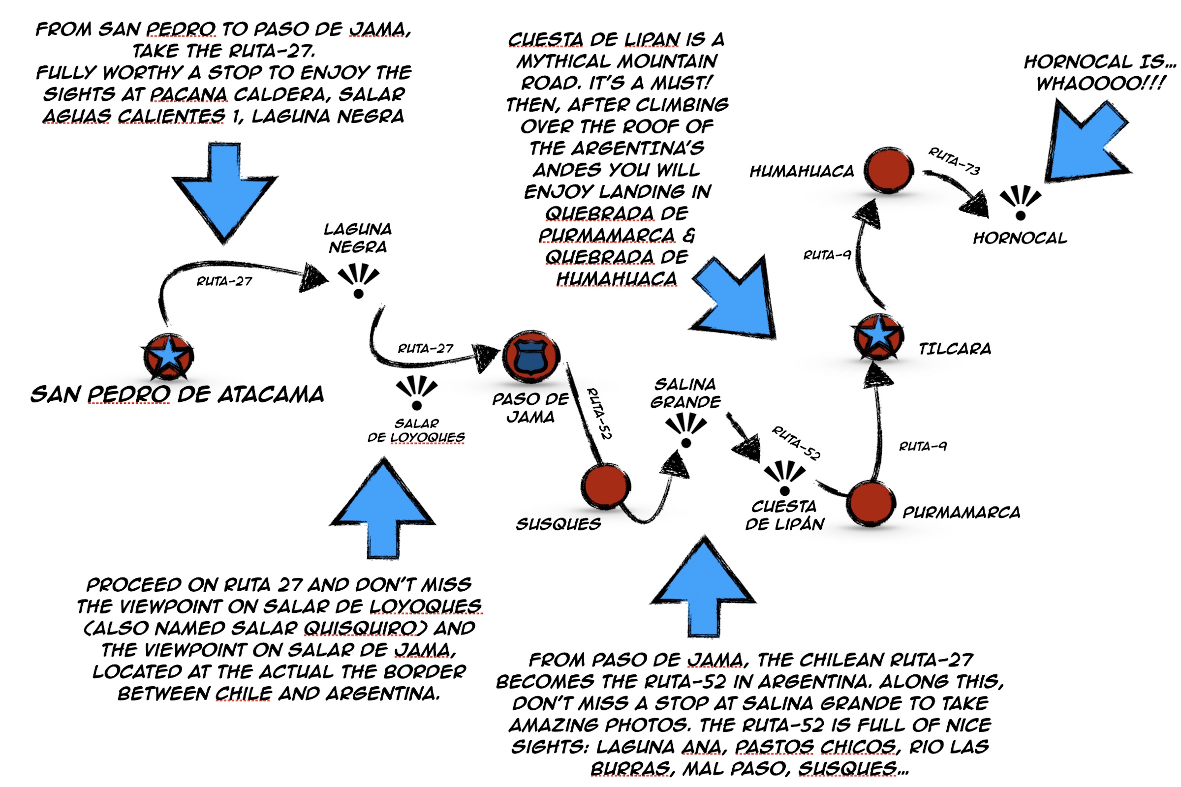
SAN PEDRO-STAGE:
- -> San Pedro de Atacama
- Valle de la Luna
- Valle de Marte
- Piedras Rojas, Laguna Aguas Caliente & Laguna de Tuyaito
- Socaire
- Quebrada de Talabre, Volcan Lascar
- Vado Putana & Machuca
- Reserva Nacional los Flamengos (Laguna Negra, Monjes de la Pacana, Salar de Tara)
Back to second part of the journey (San Pedro stage)
TILCARA-STAGE:
- -> Paso de Jama (border-post Chile/Argentina)
- Salar de Loyoques
- Cuesta de Lipán, Salinas Grande, Purmamarca
- -> Tilcara
see here info about Atacama, what not to miss & tips in a trip to Atacama

from San Pedro de Atacama to Tilcara
Here we are, the last stage of this stunning journey into the Altiplano.
Actually our trip to Tilcara isn't the last part of our tour, as the visit to Tilcara has been a roundtrip in which we crossed the Andes through Paso de Jama, travelled along the Quebrada de Humahuaca to visit the Hornocal and then back to San Pedro de Atacama, via Paso de Jama again, to have our very last adventurous day-trip at Salar de Tara.
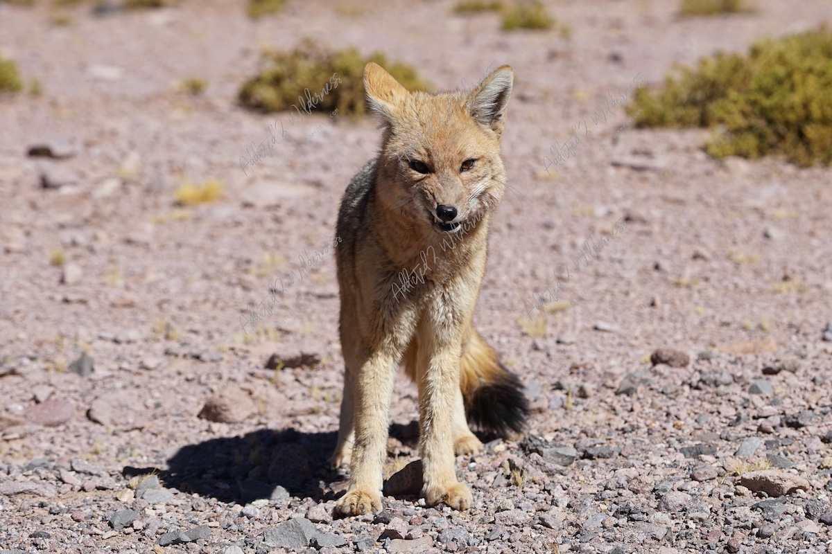
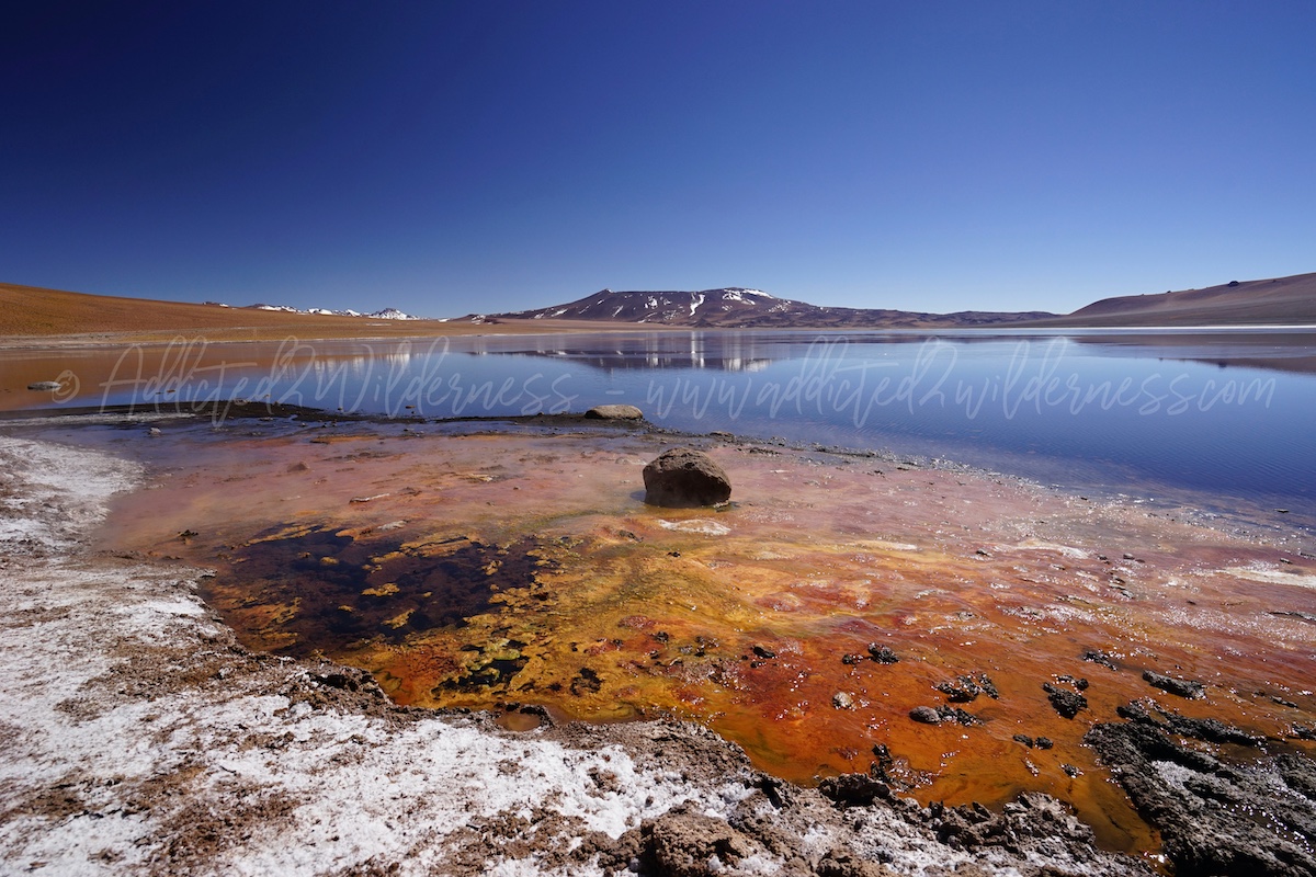
Our way to reach Tilcara is itself an highlight, we enjoyed a track fully crowded of natural wonders, stretching without stop from Chile to Argentina. We passed through the Pacana Caldera, where we enjoyed a fantastic and memorable meeting with a curious zorro andino (andean fox) who followed us for few kms, approx from the viewpoint on Laguna Aguas Calientes 1 to the banks of Laguna Negra along the Ruta-27. It has been amazing and so much empathetic encounter.
This section is fully worthy of attention, as in addition to wildlife as herds of vicunas grazing along the banks of Laguna Aguas Calientes, the landscape is absolutely outstanding.
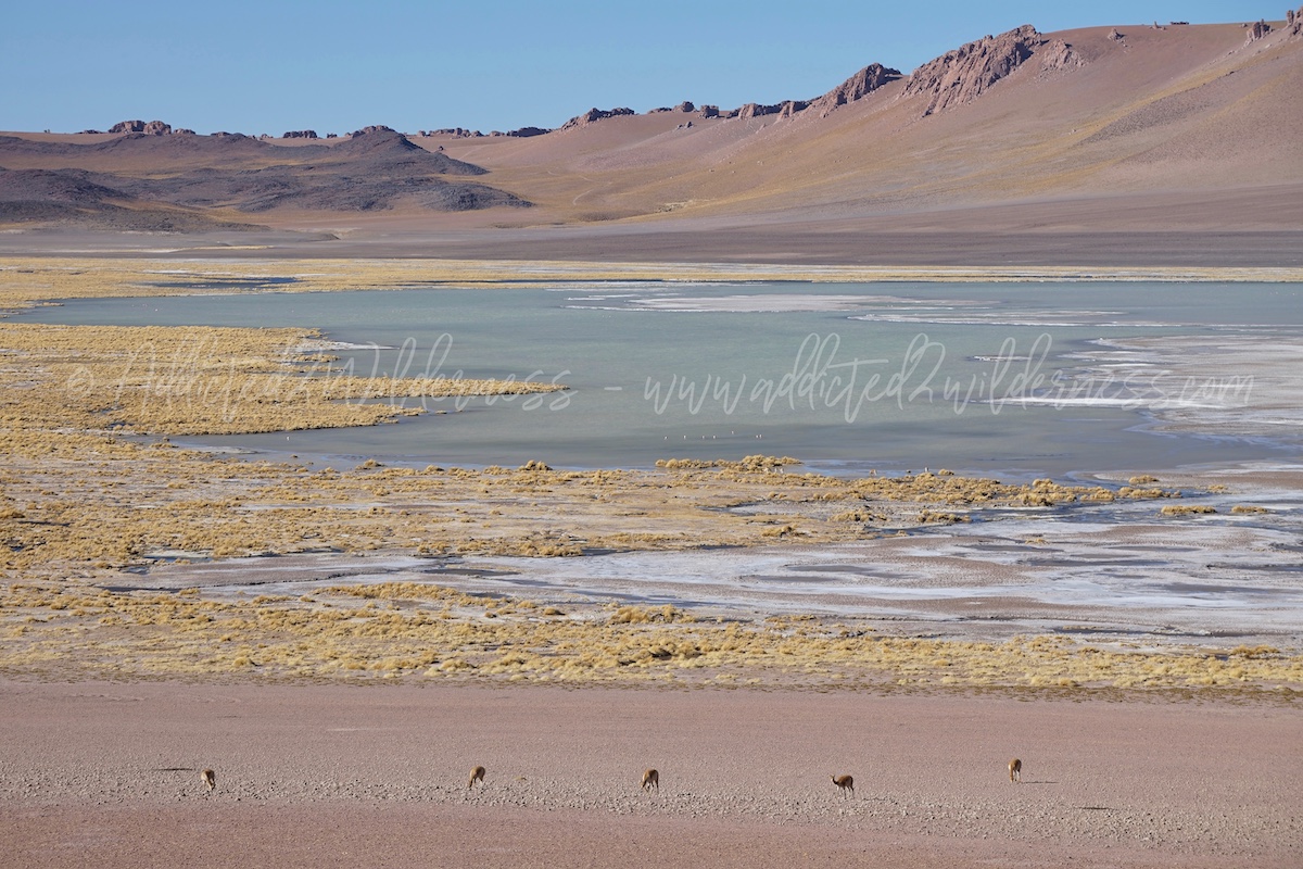
The first laguna is gifting a sense of endless wilderness nature and the second one being a perfect stage of eclectic fully colored pictures.
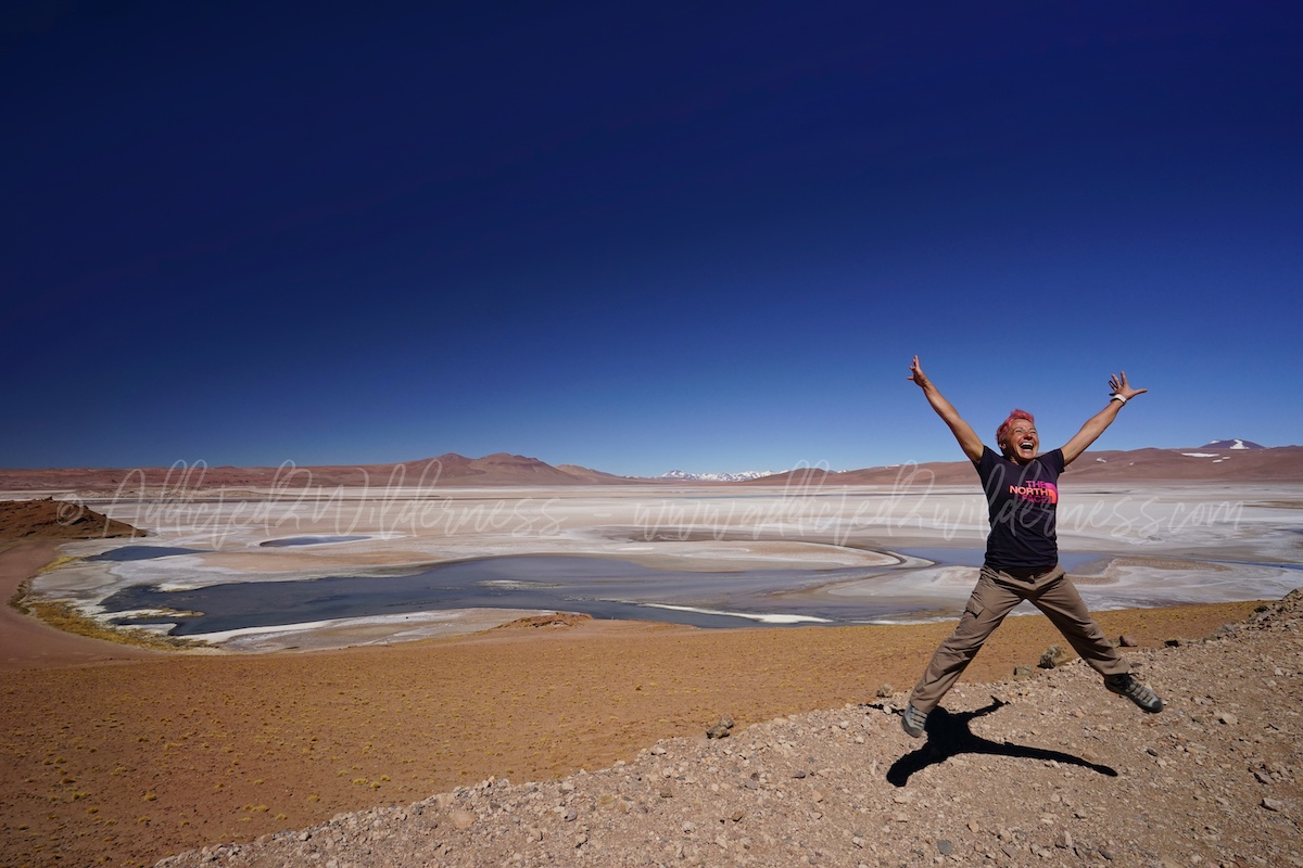
When we said goodbye to the hungry and funny fox, we drive along the Ruta-27 till the next hot-spot for our photos: Salar de Loyoques.
Unfortunately we don't have time (and no plan prepared) to venture into some off-road track to start exploring this salar. We were bringing the memory of such wonderful panorama since our first trip here. As in 2014, even this time, just a quick stop, on our way to Paso de Jama, at the mirador well nesled along the Ruta-27, where we can admire such endless beautiful landscape.
Than, let's go to Argentina. Paso de Jama is not far at all and in a 15 minutes you can reach the pass, where actually the border line between Argentina and Chile is passing. Then the border post for the check point is lying just a bit lower after few road bends. A road sign is marking the actual pass and just a little bit prior to that a mirador offer a view over the Salar de Jama.
Paso de Jama is a sort of mythical border post: it's like a gate into the Andes, where at least once in life every adventurer must pass through to set his own "Hall of Fame" of epic travels.
Actually, Paso de Jama for us is a sort place of baptism to the adventure's spirit and vocation.
You can read more about our funny and crazy issue concerning our vehicle, which occurred at the border post during our tour here in 2014. (find out here)
This time, 4 years later, we are well knowledged and everything goes smooth. Around the border post the area is a sort of small border camp, which seems to be lying on another planet, completely desert except for this small dusty colony, which works as transit way from one land to another one.
Don't miss to refuel here and then go, Argentina is in front of you.
At our right side the Salar de Jama escorts us for a while and the Andean desert is flowing fast along a straight paved road in the middle of rocky landscape covered by colored gravel.
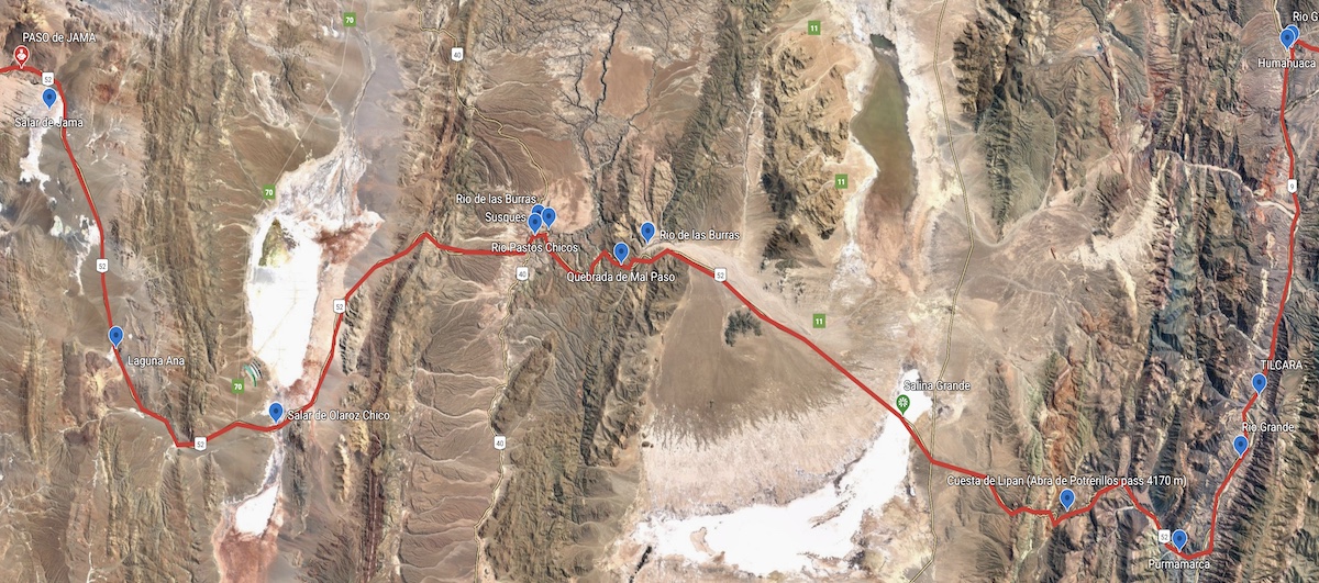
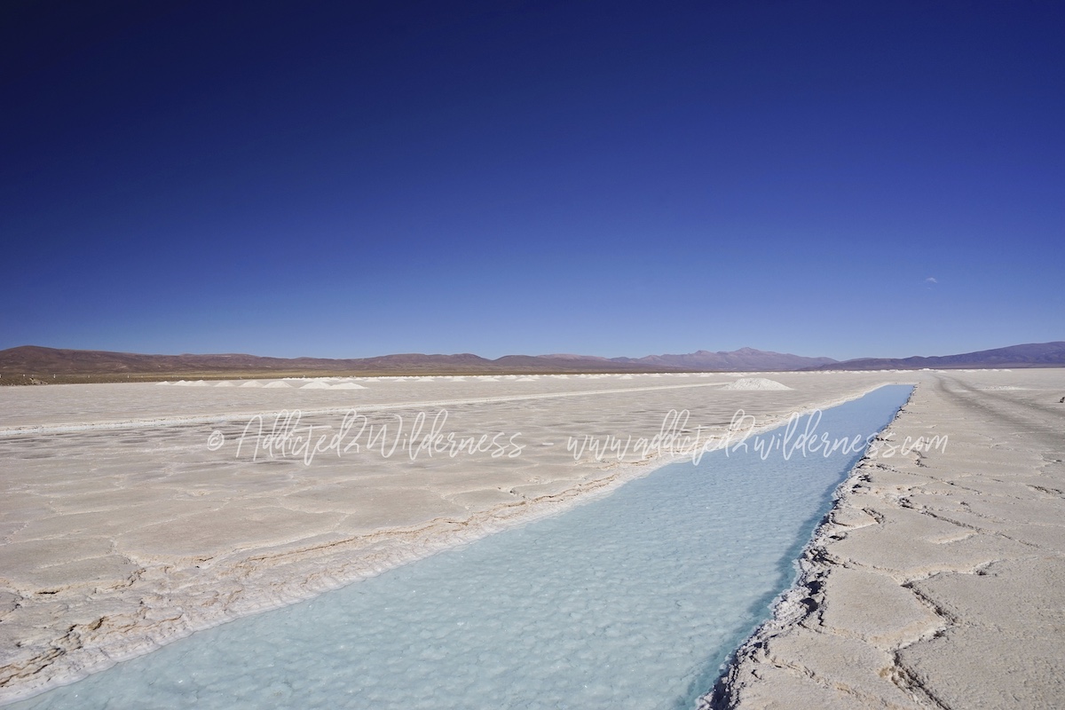
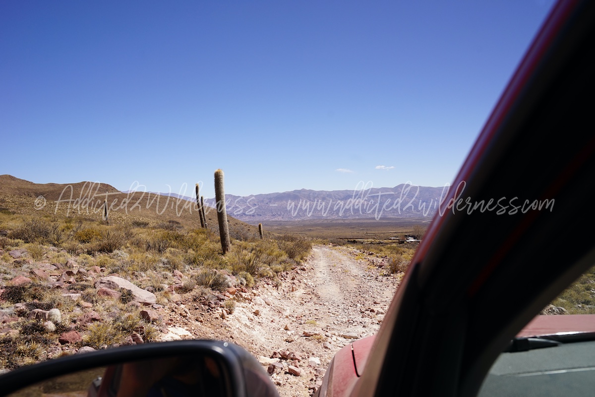
We run over this sort of alien planet and spot memorable places like Luguna Ana, the lithium salar of Olaroz Chico, Susques, the Quebrada del Mal Paso with the giant cactus, the ridges over Rio Las Burras, before arriving at Salina Grande.
Salina Grande is quite a well know actraction and actually deserve a stop over to enjoy the optical white of the salar drawn by channels of water so light-blue that it seems surreal. It's a good point to take a break on the long way drive, stretching your legs and taking amazing photos.
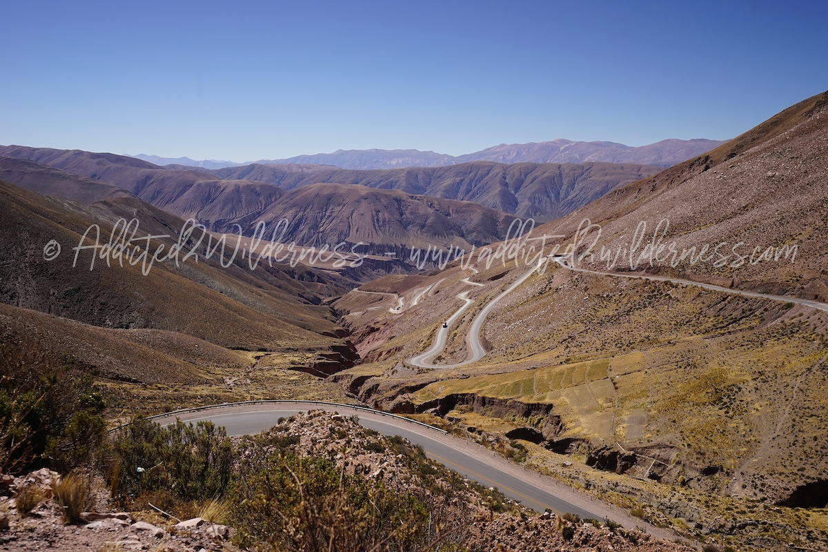
Resuming our way to Tilcara, we are in shortwhile facing the bends climbing up the Cuesta de Lipan. This epic climb is a paved road made of a endless succession of narrow bends and awesome panoramas that in few kilometers brings us up from 3450 m of Salina Grande to 4170 m of the homonym pass and down again to 2192 m of Purmamarca. It's like to be flying as an eagle over the Andean range, this scenic drive is a wonderful way to literally land to Argentina.
Piercing a sea of clouds under our sight, we pass through a sort of gate which separate the Puna highlands and the eastern Quebradas. Both mythical lands.
This second time (we drove here in 2014 as well) was perfectly sunny and we appreciated Cuesta de Lipan even more and we belive this route shall not be missed at all in an on-the-road journey to Argentina.
Driving very carefully, we descended in the narrow and fascinating Quebrada de Purmamarca, where, having enouth time would be worthy to spend some time to hike the Cerro de los Siete Colores, which sight announced us we were quickly approaching the worldwide know Quebrada de Humahuaca.
The Quebrada de Humahuaca is 150 km approx long valley generated by Rio Grande, which is the architect of this wonderland, along with the Andean ground crowded of minerals. Thanks to Rio Grande's erosion process we can nowaday admire various artist palettes painted over the mountains, which disclose their magical beauty to the visitors like colorful rainbows.
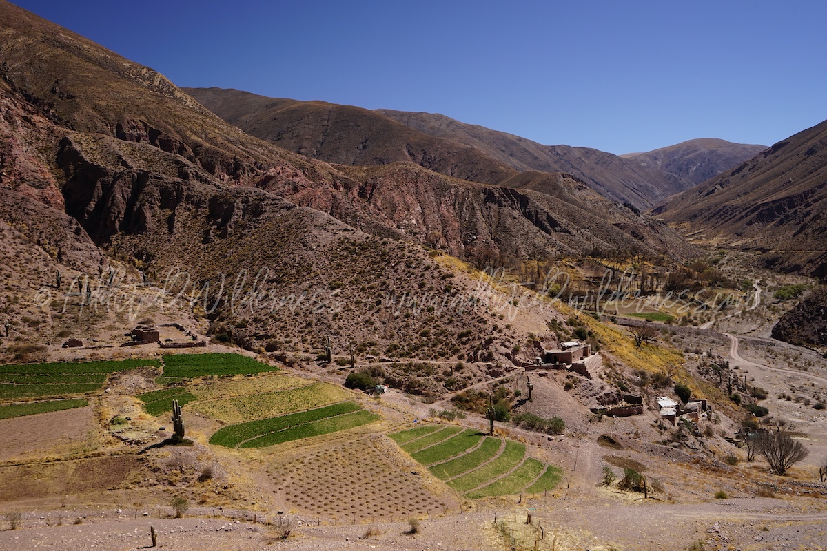
The area lying below Cuesta de Lipan is not as arid as the Puna; periods of heavy rainfall as to be taken into account, usually in summer time (mostly commencing in February). In 2014, despite was August, our drive into Quebrada de Humahuaca towards Salta, has been hit by an massive rainfall which spoiled our chance to enjoy it. This time, in August 2018 the sunny sky was perfect and the drive towards Tilcara was a wonderful trip in an iconic north-west Argentina's panorama made by a succession of ranches in countryside and dusty villages, neslted into a narrow valley with Rio Grande flowining in the middle as the big hearth of this land.
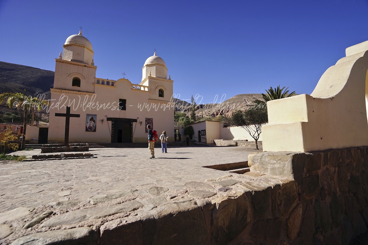
Arriving in Tilcara, its Pukara is neslted on an hill towering over the Rio Grande, showing immediately the huge history which signed this incredible land over the time.
Crossing the river and entering the town we discover Tilcara is a strange mix of feelings; at the same time it appears as a dozing village and as a swarming dusty place located on border of colonial world, explored in a past full of hope.
After a while everything sounds perfectly in line with the pure Argentina's style.
The opulent ranches in the countryside turns into a mass of shabby houses strenching along a net of roads, which from the flat downtown pass from paved and clean to dusty and soiled while climbing up the hills composing the town.
It's amazing how some town roads are perfectly suitable for a 4x4! ?
The first evening, tired from the long and fantastic crossing of the Andean chain, we took a stroll in total relaxation to the small town of Tilcara, where everything is gathered in a few streets between the market square (Plaza Cnel. Manuel Álvarez Prado) and the square of the Nuestra Señora del Rosario de Tilcara church (Plaza Sargento Antonino Peloc).
Many restaurants overlook this small urban stretch. Some were closed at the time of our visit in August, but we were very lucky to find a quality restaurant with an atmosphere that fluctuated between romantic and artistic. We went back both our evenings in Tilcara, because we tasted the wonderful feeling of being out of time to observe the World from a unique corner of pure romance.
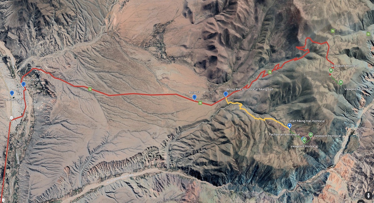
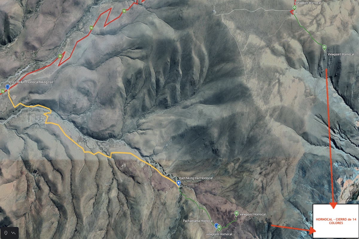
The day after, after a good early breakfast in our hotel in Tilcara, we embarked in our journey to discover Hornocal. We trip promises to be exciting, as we planned on our gps a 4x4 tour on an off-road track to have then the chance to hike reaching the panorama on Hornocal from an alternative unofficial viewpoint. Obviously, this in addition to visit the official and well know spot sight, placed few kilometers far away.
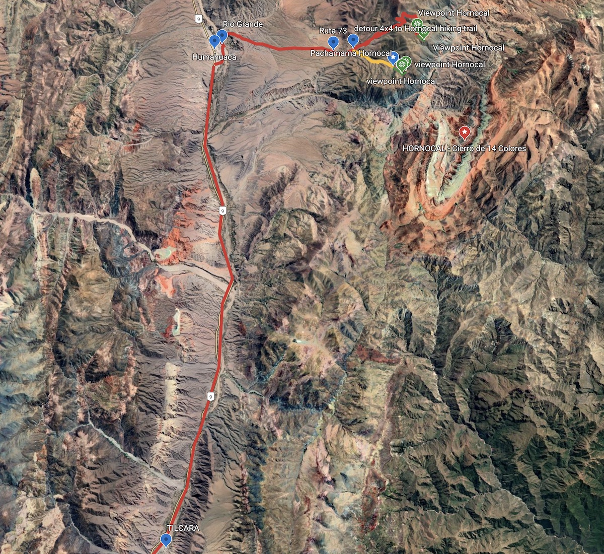
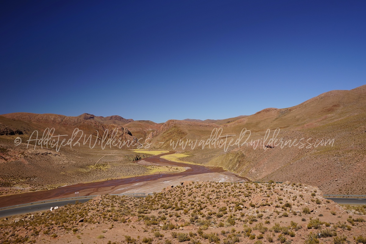
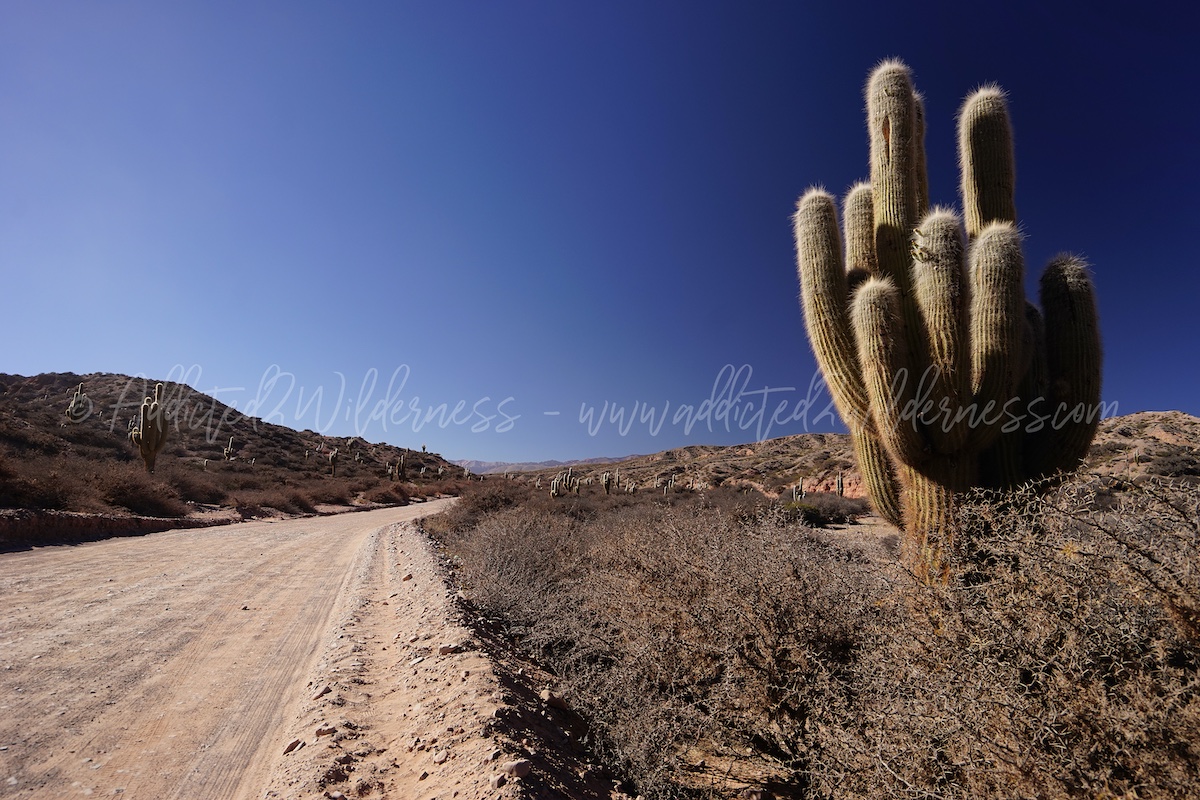
The way from Tilcara to Hornolcal is approx 70 kms and it takes 1h 20' approx itself at net of slow down on the road. The Ruta 9, stretching all along the Quebrada de Humahuaca, links easily and quite fast Tilcara to Humahuaca on a paved road. The nice and amazing section start from Humahuaca, after crossing the Rio Grande from west to east shore. The Ruta 73 on the east shore is fully gravel and in pure Argentinean style is quite bumpy in some points. The landscape, getting away from Rio Grande's riverbed, starts to become dryer and dryer and it turns into a sort of stony desert covered gaunt semiarid vegetation.
Quickly after the town of Humahuaca we enter into a scenic wilderness landscape: the Ruta 73 stretches itself through bends into dry quebradas where ephemeral waterflows had gifted home to a wood cactuses and green bushes which are strenuous fighting with deep sun and rock pebbles.
12 kms and 20 minutes approx after to have taken the Ruta 73 (which starts on left just after crossing the bridge over the Rio Grande), we arrived at point were our adventurous detour commence. The Ruta 73 proceeds along the dry riverbed of Rio de Pucara, climbing up quickly over the mountains where the "official" viewpoints and tourist-friendly hiking trails overlook the Hornocal. This last sections of Ruta 73 is nice and exciting, but having several bend on deep gravel road is not the easiest track to drive if you have a 2WD car (we have driven on this section on our way back from Hornocal). For sure it can be managed with a 2WD, but a 4x4 would be most enjoiable and safe option. By the way, as we said, we had planned our own track to fix our "personal" viewpoint on Hornocal. Therefore we decided to leave the Ruta 73 and to turn right into a bumping track which seems to be a service path for local homesteads, pointing the compass straigthly towards where Hornocal is suppose to be.
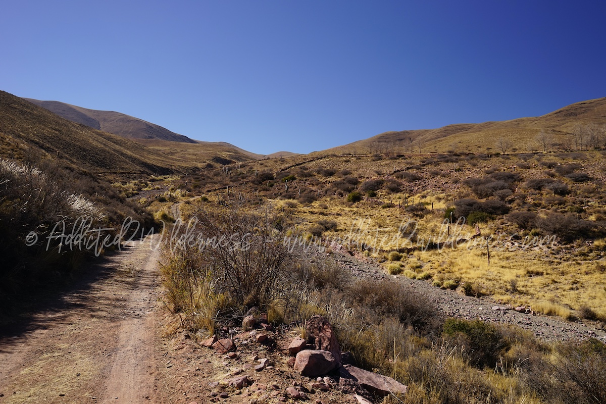
Quickly the track turns more and more challenging with streambeds to cross, mosltly dry, but with deep rocks. The way was climbing up with narrow bends along the ridge of the mountains and becoming progressively more likely to be an almost diseused muletrack.
We had to jump off 4x4 few times to check the track and investigate a bit the next sections prior to embark into a cul de sac without chance to turn back.
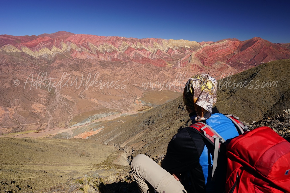
It has been a really amazing and thrilling off-road experience, which lead us closer to our personal own viewpoint on the Hornocal. We parked our vehicle hovering on the edge of the mountain, just off the muletrack, we put on our backpacks and with all the necessery stuffs for a safe hike we started our trekking heading straightly the mythical Cerro de 14 Colores, well known as Hornocal.
With the sun shining high into the sky, despite the high altitude (we hiked from 3700 m approx to 4050 m approx) it was quite hot and the environment around us made by red & grey rocks, dry quebradas populated by cactuses, yellow grassland with haggard bushes boosted the feeling of a completely wilderness sun-hitted land. The trail has been quite strenous, even more if you consider the that we were totally unsure if this was actually leading us to an open sigth on Hornocal or if it was going to turn into a blind sight on the endless various mountains ridges only.
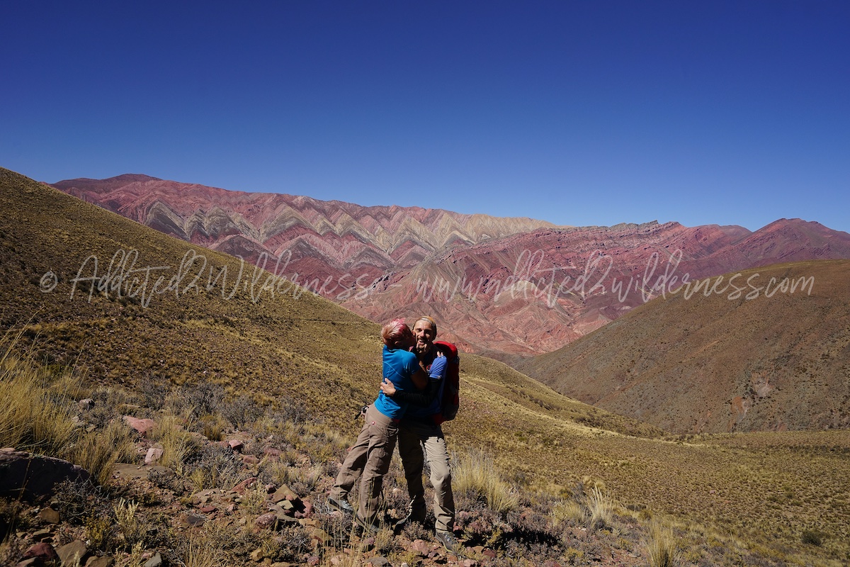
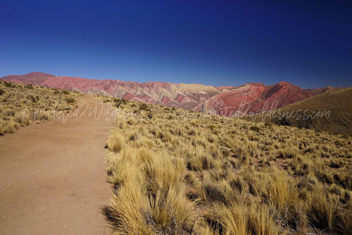
We haven't given up at all, and, as marked on our map, we hiked to Pachamama's site, which is where for the first time Hornocal disclosed itself to our sight.
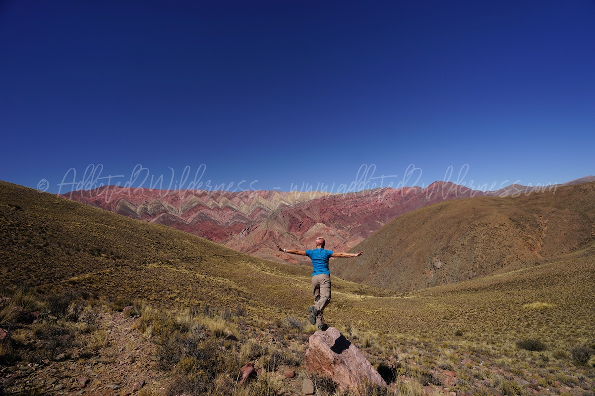
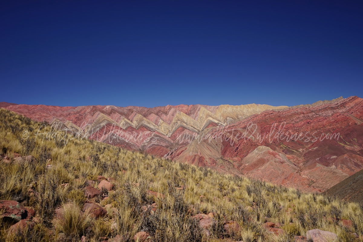
We immediately understood why that point has been choiced as location for Pachamama (tribute to motherearth). The Cierro de 14 Colores is breathtaking, it is astonishing. It is absolutely crazy: a magic rainbow with so many nuances, mixed in a deep saturation, was running from us towards a perfect prospective way out.
Stunned by such fairy beaty, full of admiration for the Nature, after to have taken various photos, we decided to keep on hiking. From Pachamama location, there are two option: hike down towards the deep valley dividing the mountains where all the viewpoints overlooking the Hornocal and the Hornocal itself or hike up towards the summit closest to us, in direction of the "official" viewpoints and touristic site. The first would have given us the chance to get closer and closer to Hornocal, but we decide to hike up and discover other unconvention good viewpoints (walk left from Pachamama).
This last section of our hiking has been a bit more strenuous, because the path climbs much steeper, but also because we had few kms in our legs under a sun becoming warmer and warmer. In any case it was an absolutely worthy choice: the view on the Horncoal is wonderful! From the highest point of our trek we could admire the Cerro de 14 Colores perfectly in front of us; we could look into the eyes of an infinite and vivid rainbow.
Excited to have embarked on our own trail and to have discovered an unconventional view of this geological wonder, we spent some time contemplating the view, for some memorable photography, for a frugal lunch and to recover energy for the path of return. Our day is still young and now on our roadmap we have fixed the visit to the official viewpoints and touristic site.
Back to our 4x4, we tackled the off-road route in the opposite direction and the descent often hides a few more pitfalls than the ascent. Nothing that can't be managed while having fun, just with a little bit of the right attention.
In a short time we take Ruta 73 again and head east again. A few bends, but steep and busy, where the increasingly gravelly Ruta 73 climbs through the mountains, and we find ourselves at the official vantage points marked on the maps.
From here a series of simpler and more intuitive paths lead to a series of excellent views of the Hornocal. The view is already extraordinary at the first clearing, but going down to the second the context becomes even more beautiful. The dirt path, which becomes progressively steeper along the mountain, is drawn between golden meadows dancing in the wind.
Moving away from the car park, going down this path, you can appreciate the surrounding environment and this fantastic place even more, as most tourists are lazy and stop at the first viewpoint.
Unfortunately, when we reached the second viewpoint, where you can enjoy a breathtaking view of the Hornocal, on the day of our excursion there was a musical group with the camera crew to shoot a video clip. Beyond the initial folklore, this bothered us a bit, as such a cathartic and wonderful place should be enjoyed in solitude and total tranquility. In any case, this did not prevent us from once again pausing enchanting in front of this natural monument of indescribable beauty and from getting lost in its contemplation.
The ascent is not really a walk, the path is steep, but the place is so extraordinary that it makes us float in the air with our mind.
Ultimately, the official viewpoints offer a magnificent view with perfect angles and framing, with good and practical accessibility, but we feel more enthusiastic about getting to discover a panorama like Hornocal's one after a strenuous walk on deserted paths: being able to enjoy the Nature's majesty in loneliness is unmatchable. Therefore, if you plan a visit to Hornocal, don't miss the official tourist site, but allow half a day for a memorable trekking into the wilderness.
Read more...